
The Cotswold Canals run for 36 miles across the southern Cotswolds connecting the River Severn with the River Thames. They are restored in some areas, wild in others. They were built in the 18th century as two canals: the Stroudwater Navigation and the Thames and Severn Canal. The canals were used for 100 years, but use declined after the railway was built. The restored parts are not long enough for boating but a good footpath goes along most of the canal. The canal run near the River Frome for much of the way.
There were 56 locks along these canals. A steam engine maintained the water levels. The towpath alongside the canal was for the horses or donkeys that pulled the barges. Now it is used as a footpath. The canals linked in Brimscombe at an inland transfer port.

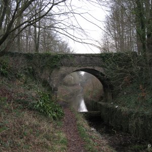
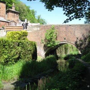
A bridge near Chalford.
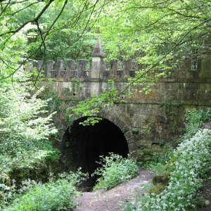
Sapperton Tunnel: One of the features of the Thames and Severn Canal is the Sapperton Tunnel which runs from Sapperton to Coates under the highest part of the Cotswold Hills. The tunnel was 2.17 miles (3.49km) or 3817 yards long, 14 feet wide and 15 feet high. When the tunnel was completed in 1789 it was the longest tunnel in England. There was no towpath through tunnel, so barges were "legged" through (men used their feet on the tunnel walls to push the barge).
The tunnel has collapsed but the portals at either end were restored in the 1970s. The Daneway Portal at western end is Gothic style with battlements. The Coates Portal on the eastern end is of classical design.

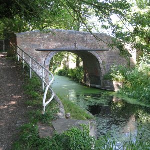
Coates Portal, entrance to the tunnel (east side).
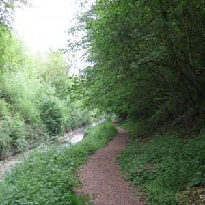
Walking the Canals: There is a good footpath along much of the canal, but it is best to start east of the M5 (park at Blunder Lock). From there the path is good all the way to Stroud and on to Chalford and the tunnel entrance at Sapperton. From Sapperton you can walk to Coates at the other end of the tunnel. The path after this gets a bit rough, but is better again further on. The prettiest part to walk is from Chalford (park along the A419) to the Daneway Portal near Sapperton.
Location: England - Gloucestershire - Stroud
Website: Cotswold Canals Trust - Formed in 1972 to restore these canals for recreational use.
Google Map

 goo.gl
More Photos
There were 56 locks along these canals. A steam engine maintained the water levels. The towpath alongside the canal was for the horses or donkeys that pulled the barges. Now it is used as a footpath. The canals linked in Brimscombe at an inland transfer port.
- The Stroudwater Navigation opened in 1779 to carry coal to the cloth mills in the Stroud area. It started at the River Severn at Framilode (near Saul Junction and Frampton-on-Severn) and ended at Wallbridge near Stroud (7 miles). The Stroudwater Navigation was abandoned in 1954.
- The Thames and Severn Canal opened 10 years later, in 1789, to connect the Stroudwater Navigation to the River Thames at Inglesham near Lechlade (29 miles). The canal was abandoned in 1933. There is a 2.17 mile tunnel, now collapsed, on this part of the canal.
- Saul Junction near the River Severn (there is parking). Here the canal crosses the Sharpness-Gloucester Canal.
- Blunder Lock, east of the M5 (off the A419 on Spring Hill, the first roundabout east of the M5 entrance). There is parking.
- Ebley where the towpath is in good shape (park at Ebley Mill, the Council offices).
- Stroud where the canal passes under the A46. Park in one of the Stroud car parks.
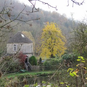
- Brimscombe where you can see the transfer port.
- Chalford (park along the A419).
- Daneway (park along the road and walk to the Daneway Portal).
- Coates. Park at The Tunnel House Inn. The Coates Portal is just off the car park.
A bridge near Chalford.
Sapperton Tunnel: One of the features of the Thames and Severn Canal is the Sapperton Tunnel which runs from Sapperton to Coates under the highest part of the Cotswold Hills. The tunnel was 2.17 miles (3.49km) or 3817 yards long, 14 feet wide and 15 feet high. When the tunnel was completed in 1789 it was the longest tunnel in England. There was no towpath through tunnel, so barges were "legged" through (men used their feet on the tunnel walls to push the barge).
The tunnel has collapsed but the portals at either end were restored in the 1970s. The Daneway Portal at western end is Gothic style with battlements. The Coates Portal on the eastern end is of classical design.
Coates Portal, entrance to the tunnel (east side).
Walking the Canals: There is a good footpath along much of the canal, but it is best to start east of the M5 (park at Blunder Lock). From there the path is good all the way to Stroud and on to Chalford and the tunnel entrance at Sapperton. From Sapperton you can walk to Coates at the other end of the tunnel. The path after this gets a bit rough, but is better again further on. The prettiest part to walk is from Chalford (park along the A419) to the Daneway Portal near Sapperton.
Location: England - Gloucestershire - Stroud
Website: Cotswold Canals Trust - Formed in 1972 to restore these canals for recreational use.
Google Map
Cotswold Canals Trust Visitor Centre Wallbridge · Bell House, Wallbridge, Stroud GL5 3JS, United Kingdom
★★★★★ · Historical landmark
More Photos


Cotswold Canals
- Pauline
- 14
The Cotswold Canals run for 36 miles across the southern Cotswolds connecting the River Severn...