• CONTACT US if you have any problems registering for the forums.

Scotland The Moray Coast Fishing Villages

The series of small fishing villages along the Fife coast are a popular tourist destination for many, especially those based in Edinburgh. What many people don’t realise is that there are equally as attractive villages on the Moray coast in the north east of Scotland. They get few visitors, but can easily be visited as a day from either Aberdeen or from Inverness.

This just covers the series of small villages, ignoring the town of Fraserburgh, which is still the biggest shellfish port in Europe with a busy commercial harbour.

Many of the settlements were established in the C18th when crofting families cleared from inland estates to make way for their landlord's sheep, were moved to the coast. It is a hostile and rocky coastline and settlement grew up around the mouths of streams where a small harbour could be built. Families fished from boats owned by the landlord. They used lines to catch haddock, whiting and mackerel. By the end of the C19th some fishermen had managed to save enough money to build their own boats. However larger boats appearing in the first half of the C20th were unable to operate out of many of the small harbours and fishing declined rapidly. Now there is little fishing from many of the settlements, apart from some crab and lobster and harbours are full of small pleasure boats.

ROSEHARTY

The first settlement is Roseharty which is thought to have been settled by Danish fishermen in the C13th or C14th, making it one of the oldest of the villages. It is still overlooked by the ruins of the C16th Pitsligo Castle

By the C19th, there were 90 fishing boats based here, but when the railway arrived at Fraserburgh, all the fishing moved there.

Roseheary has two harbours. The older and smaller harbour its two piers is to the west and surrounding streets are lined with traditional fishing cottages.

full


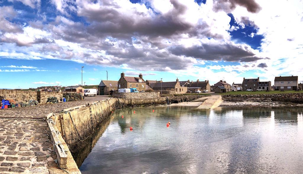
The later harbour to the east is sheltered by single long breakwater and is still used for some fishing.

PENNAN

Pennan is a a small settlement huddled under red sandstone cliffs beneath the plateau behind. The road drops steeply down the cliff to the settlement. There is a small harbour at the mouth of the stream which has cut a deep gorge down through the cliff. This used to be an important fishing harbour, but now it is mainly pleasure boats although there were a few lobster and crab pots around the harbour.

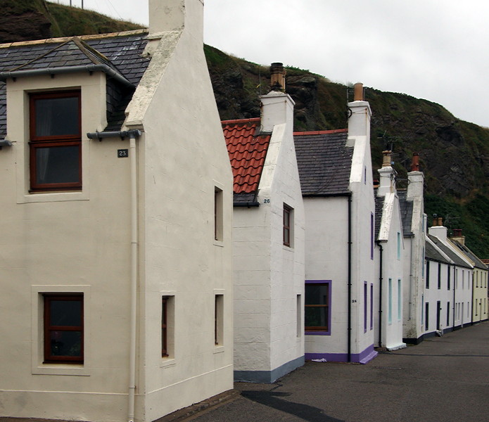
There is just enough space beneath the cliffs for a single row of houses.

full


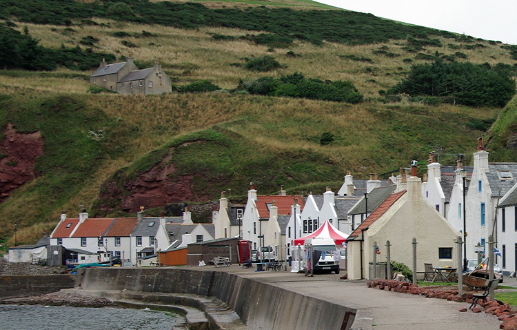
These are built with the gable end facing the sea to reduce exposure to the elements.

full


There is just enough space for the road and narrow grassy area in front of the houses protected by a concrete sea wall. The wire lines are now used to hang out washing rather than nets.

There are many incomers living here. There are several self catering properties, B&B and the Pennan Inn which serves lunches and evening meals. A sign on the wall explains that the film “Local Hero” was shot here.


Locals park along the village street, but there is a small car park at the end of the street by the Village Hall which has very clean public toilets. The new septic tank is here with information boards about the installation and how it works to improve the quality of water being released into the bay and the benefits to marine life.
 
Last edited:
CROVIE

Crovie is an attractive, small fishing village huddled below the cliffs on the Moray Firth about 15 miles west of Fraserburgh. The houses are built on a narrow ledge above the beach. There is just room for a narrow footpath of boulders and cement above the shore, which gives access to the houses. This also doubles up as a sea wall.

full


There is a steep road dropping down to the village with a limited amount of parking for residents. Visitors are asked to park their cars in the car park above the village. From here a footpath with wooden steps drops down to the village by the mouth of the stream. This is one of the few flat and grassy areas in the village and the only place boats can be pulled up out of the sea.

full


The small harbour is very exposed with only a single breakwater to provide shelter.

full


A built up pathway of boulders and cement runs above the shore line giving access to the houses and also acts as a sea wall.

full


full


full


The small, mainly stone houses with dormer windows with slate or pantiles roofs are built gable end to the sea to protect them from the worst of the elements. Many have wooden shutters. Some have a small shed built on at the front. A narrow passageway between the houses leads to the front door. Each property has its own sewage outlet to the sea. This explains why nearby Pennan is so proud of its new septic tank.

full


The buildings are typical of fishing communities established along the Moray Firth in the C18th. Crofting families cleared from inland estates to make way for their landlord's sheep, were moved to the coast. They fished from boats owned by the landlord. They used lines and caught haddock, whiting and mackerel. By the mid C19th, some fishermen had managed to save enough money to built their own boats and by the end of the century there were about fifty owner-operated boats sailing from Crovie.


The first half of the C20th saw a gradual decline in Crovie's fishing fleet in the face of competition from the larger, more effective steam drifters that were unable to operate from the poor harbour at Crovie. The number of boats fell. The final straw was the great storm of 30th and 31st January 1953.

The storm had been building since the previous night resulting in hurricane force winds and huge seas. The path to Gardenstown, the main access to and from the village, was washed away together with stretches of Crovie's sea defences and a number of houses and sheds at the west end of the village. Many people left or abandoned their houses, moving to round the bay to Gardenstown.


A new road was built down to the village with the cleared western end of the town providing resident’s parking. Crovie is now mainly a holiday village. The restrictions placed by its location on development throughout its history, plus the halt to commercial activity in 1953, have left Crovie as one of the best preserved fishing villages in Europe. There is a post box and red phone box, but no other services. It is well worth parking and walking down to the village to explore.
 
GARDENSTOWN

Gardenstown is one of the larger of the fishing village along the Moray Firth. In 1900 there were 92 boats operating out of the harbour, but this had fallen to 50 by 1920. The large stone built building was used for storage and mending nets. Although the herring fleet was always based in Fraserburgh, boats were often moored here. For fishing to remain a viable way of life, boats had to increase in size, operating out of either Fraserburgh or Macduff which had larger harbours. By the 1980s and 90s there was very little activity around the harbour.

New pontoons were installed in 2005 providing up to 80 berths. A few small fishing boats still use the harbour, but it is now used mainly by pleasure craft. A bill board advertises pleasure trips to the RSPB reserve at Troup Head, the second largest gannet colony in Britain.

full


full


Seatown, dating from 1720, is to the west of the harbour and was the traditional fishing village. It looks and feels a little like Crovie as the houses were built on a ledge along the base of the cliffs. Streets are narrow with alleyways between the houses, with closes linking up the narrow streets.

The newer houses climb up the hillside and are dominated by the bulk of the large stone built St John’s Church, dating from 1875.

Beyond the town on the opposite hillside is the cemetery and the remains of the C16th St John’s Church, which predates the village.


MACDUFF AND BANFF


Macduff and Banff are on either side of the River Deveron, and are linked by the elegant seven arch Deveron Bridge.

Macduff is a pleasant stone built town and is one of the best fishing harbours along the Moray Firth and is used by commercial marine vessels as well as smaller vessels. It was the last place in the UK building deep water wooden fishing boats.

The Macduff Marine Aquarium features sea life from along the Moray coast, as well as local shipwrecks.

The best views of the town are from the C19th Doune Church which was built on a hill overlooking the harbour.


Banff with its stretch of golden sand is very much dependent on the tourist trade.

It is a lot older than Macduff, having been established in the C12th and was a Royal Burgh. Although it was a small port, the harbour silted up in the 1800s . It has recently been developed as a marina.

Banff is one of the best preserved townscapes in Scotland with a Georgian ‘Upper Town’.

Just to the south of Banff is Duff House, a Georgian building that displays a wonderful collection of paintings from the National Galleries of Scotland.
 
WHITEHILLS

Whitehills is sheltered from the east by Knock Head.

There was a fishing village here from the 1700s although it didn’t have a harbour at first. Boats were pulled up on the shore. Fishwives would carry their husbands out to the boats on their backs to avoid having to put to sea in wet clothes.

The harbour was eventually built at the end of the C19th. Fishing survived until 1999, and the fish market can still be seen on the quayside. The harbour has since been redeveloped as a marina.

The small stone fishermen’s cottages are laid out in a regular grid pattern.

full


full


The parish church with its very distinct small tower came from Banff when a redundant United Presbyterian Church was dismantled and reassembled in Whitehills. The village is trying to promote tourism by a series of information boards around the settlement.

full


PORTSOY


Portsoy was one of the oldest harbours to be built along this stretch of the Moray coast in the C15th. The harbour was replaced in 1692 by the Lairds of Boyne with

The construction used large stones set vertically, apparently because it was believed that this made them less likely to be washed away by the sea. It seems to have worked as the old harbour is still there, although it is now replaced by a newer and larger harbour to the east.

Two breakwaters provide a very sheltered anchorage for the old harbour with a small sandy beach at the head.

full


Bright pink tufts of thrift and white flowered scentless mayweed were growing between the stones of the harbour wall. Rocks were covered with bright orange lichens. It is surrounded by impressive buildings including houses and warehouses, dating from 1600-1700.

To the west of the old harbour is a small headland with the remains of an old building. This has views of the rocky and very exposed coastline. Above the cliffs, the land is very flat with mainly arable farming with large fields of grain.

full


Portsoy had been a busy harbour and trade was varied. As well as fish, they exported locally produced thread and linen to England and locally quarried green Portsoy marble. Some of this even found its way into the fixtures and fittings of Louis XIV's Palace of Versailles. Coal was imported.


The New Harbour was built in 1825 to meet the demands of the herring boom and the volume of trade going through Portsoy. This had to be rebuilt following storm damage in 1839.

full


As elsewhere along the coast, fishing and trade declined through much of the 1900s. There have been a number of regeneration projects from the 1970s which have succeeded in giving Portsoy its heart back with an attractive centre with streets winding down to the old harbour.

 
Last edited:
FORDYCE

Just inland from Portsoy is Fordyce, which still retains its medieval street plan with stone built houses surrounding Fordyce Castle built in 1592. It is a typical L plan castle with gun loops, built by Thomas Menzies, Laird of Durn, and one time Provost of Aberdeen. It now offers self catering accommodation.

full


full


Houses have dormer windows with slate roofs and are well cared for. Many have attractive flower gardens.

full


The remains of the C13th church are in the churchyard behind the castle. It was dedicated to Talarican (St Tarquin) a Celtic saint. Now in ruins, with the nave long gone, the tower and chapels stand isolated from each other.

full


It was originally a small rectangular building with a porch on the south wall, with a room above. A chapel, St Mary’s aisle, was later added on the south side. After the reformation, the nave was used as the parish church and the chancel became to burial aisle of the Ogilvy family. In the C17th a bell cot was added to the porch and the room above was used as a prison. The Arbercrombie family added an aisle to the north side of the church.


With an increasing population in the late C18th, the church was abandoned and a new and larger church was built at the other end of the village in 1804. Most of the old church was demolished for building stone, although the porch survives. This now looks more like a tower with a small bell cot. It has carefully shaped red sandstone corner stones and an archway through it. The rest is rough masonry. External stairs lead to an upper room which is now an exhibition space ( but was closed when we visited).

full


full


Near it is the roofless St Mary’s or Durn aisle, which was on the south side of the nave. It is now a roofless building with a locked wooden door which has a small iron grille in it. This was the burial aisle of the Ogilvy family and on the wall opposite the doorway is a very eroded stone memorial.


The Abercrombie aisle was on the north side of the nave. This is still roofed and the door was open. On the wall is a stone memorial to James Abercrombie of Glassnaugh, who was deputy governor of Stirling Castle and died in 1781. There is a long eulogy detailing his work and virtues. Now he shares his resting place with the pigeons.


Built on the side are two roofless chapels, separated by a stone wall. One has an empty wall tomb under a carved ogee arch. This is described as the Birkenbog Tomb, which dates back to 1505. The chapel next to it has a similar wall tomb with a statue of a knight in armour. His uncrossed legs are resting on a dog and his hands are held in prayer. There is a small carved shield at the top and also at the bottoms of the arch. This is the Findlater and Boyne Tomb, dating from 1510. The Latin script on the front edge of the tomb translates as: "Here rest two honourable men, James Ogilvy of Deskford, and James Ogilvy, his son and heir presumptive. The former died 13 February 1509 and the latter 1 February 1505. Pray for their souls".

full
 
Last edited:
CULLEN

Cullen is an attractive town at the mouth of Deskford Burn. The Great North of Scotland Railway connecting Portsoy and Elgin had run through Cullen. Closed in the aftermath of Beeching, the three great viaducts still dwarf the town.

full


The main road drops down through the newer town, which is attractive with wide streets and attractive stone buildings. There is no litter or graffiti. There is a large square with the Mercat cross and a good range of small family owned shops. The chain stores haven’t arrived here yet. Just above the viaduct on Seafield Street is The Ice Cream Shop, regarded by many as the best in Scotland.


The harbour is below the viaduct and there is a triangle of grass lined with tall stone houses. The original harbour was built by Thomas Telford in 1817 as part of a government programme to improve communications and create employment in the north of Scotland. In 1842 it was described as one of the best harbours along the Moray Firth, even though it dried out completely at low tide. It imported coal, salt (for curing fish), staves (for casks) and barley (for whisky making). It exported herrings, dried fish, timber, oats and potatoes.

full


The town specialised in smoked haddock and there were three large curing houses. The local dish of Cullen skink soup probably dates from this time.

Seatown, the original settlement, is here. This was a planned town and is best seen from above on the patch of grass along Seafield Street and Bayview Road. Small fishermen’s cottages are arranged on a grid patter with narrow alleyways between them. They are small single storey buildings with dormer windows. Those along the shore have their gable ends turned towards the sea.

full


Coloured render has been applied over the joints of the stones on many of the cottages but not over the stones themselves, resulting in a patchwork effect.

full


Beyond is a long stretch of sand, popular with holiday makers.

full

 
Last edited:
PORTKNOCKIE

Portknockie is unusual as the village is built on top of the cliffs above the harbour as there was no room for housing at the base of the cliffs. It is a very exposed coastline.

full


The town began to grow in the 1770s when fishermen from Cullen settled here and it grew rapidly during the herring boom of the 1800s. The town is a planned town with a regular grid street pattern. Houses are small although there are some larger captain’s houses with external steps up to the net loft.

full


The harbour is sheltered by the rocky bluff of Green Castle and is reached down a steep road from the village. This was once a Pictish stronghold and there are also the remains of an iron age fort.

There is still some fishing out of here, although it is also used by leisure craft. There is a small sea water paddling pool in the outer harbour.

full


There is a pleasant walk around the headland to views of the natural sea arch of Bow Fiddle Rock.

There are details of a walk around Portknockie here.


FINDOCHTY


Findochty is described as a non-touristy settlement which has been settled since the 1400s, making it one of the oldest of the fishing settlements.

full


The coast line is rocky with little shelter against the elements

full


Findochty expanded rapidly during the C18th and C19th and by the mid C19th there were over 140 fishing boats, but with the expansion of nearby Buckie which provided a better harbour, much of the fleet moved there.

It has a large and very well sheltered harbour which is now full of pleasure boats.

At low tide there is an expanse of sand beloved by local children. There are a few lobster and crab pots along the harbour wall. At the end of the harbour are larger captain’s houses.

There is a white church with a manse set on a rocky outcrop at the eastern end of the town. To the west is a stone church on a smaller mound. We also saw a Salvation Hall and small chapel. Religion was important here.

The oldest part of the settlement is beyond the church. The small stone houses with dormer windows are arranged on a grid pattern. Many have brightly painted corner stones and window surrounds.

full


full


Sandy Creek on the east side of the headland seems to be a small natural harbour here with a grassy area to pull up boats. Beyond is a large sandy bay guarded by rocks.


BUCKIE


Buckie is the largest fishing settlement along the Moray coast and is made up of several small fishing villages which have grown into each other. The original settlement dates from at least C12th and was built away from the coast in the area of Rathven. A new and larger settlement grew up in the late C18th and early C19th settlement to the west. Fortunately the busy A990 runs along the coast and misses the main town centre.

The harbour was built in the late C19th and was one of the finest in Scotland. A small fishing fleet still operates from here and it is also a commercial port with timber, grain and other commodities are shipped from here as well as activity linked to offshore renewable energy. It still has a shipyard.

Buckie also maintains a thriving and busy town centre with a lot of independently owned small shops.
 
Last edited:

How to Find Information

Search using the search button in the upper right. Search all forums or current forum by keyword or member. Advanced search gives you more options.

Filter forum threads using the filter pulldown above the threads. Filter by prefix, member, date. Or click on a thread title prefix to see all threads with that prefix.

Sponsors

Booking.com Hotels in Europe
AutoEurope.com Car Rentals

Recommended Guides, Apps and Books

52 Things to See and Do in Basilicata by Valerie Fortney
Italian Food & Life Rules by Ann Reavis
Italian Food Decoder App by Dana Facaros, Michael Pauls
French Food Decoder App by Dana Facaros, Michael Pauls
She Left No Note, Lake Iseo Italy Mystery 1 by J L Crellina

Share this page

Back
Top